Theories for the Formation of Grand Canyon (Sidebar 3)

Visitors to the Grand Canyon are frequently overcome by the immensity and beauty of the Canyon, and are also indoctrinated with the one-sided uniformitarian theory of its formation. There are three major theories for the formation of the Grand Canyon. Young Earth creationists believe that the Grand Canyon was formed catastrophically as a result of the great Flood of Noah's time. Following is a description of the general topography surrounding the Grand Canyon and a discussion of the three theories of canyon formation.
Topography of Northern Arizona:
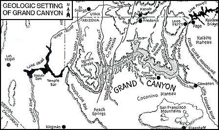
The topography of Northern Arizona provides unique challenges to theories for explaining the Canyon's formation, especially by uniformitarian processes. The Colorado River has an enormous drainage basin extending as far north as Wyoming. The area where the Grand Canyon was etched is a raised monocline (U-shape) through a high plateau (Figure 1). The monocline is called the East Kaibab Monocline (or the Kaibab Upwarp), and its plateau is 3,000 feet above the land to the east of the Canyon. The Grand Canyon runs through the monocline just south of the plateau (highest point), which explains why the north rim is higher than the south rim. There is evidence that the Grand Canyon was eroded after the rock was raised into the Kaibab Monocline.
Figure 1

References
Austin, S.A. 1994. "How was the Grand Canyon Formed?" in The Grand Canyon: Monument to the Flood Institute for Creation Research, Santee. p. 83-110.
 
| 

