| |  |
| |
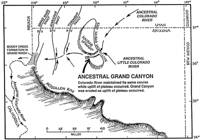
A second observation is even more startling than the first: Grand Canyon cuts through, not around, a great plateau land. The well-developed drainage basin of the Colorado River (see Figure 5. 1) has its headwaters in elevated areas, as all rivers do, but, unlike most rivers, it has high plateaus adjacent to it, one-third of its total length from the sea. Most rivers have broad lowland areas that close to the sea. We would expect the Colorado River to have established its course around, not through such an elevated area standing in its path to the sea. Observation of the extreme eastern portion of the Canyon shows the magnitude of this river-location problem. At Grandview Point and Desert View Tower, we observe the Colorado Plateau north and east of Grand Canyon. The plateau, with its surface of Kaibab Limestone, to our astonishment, rises from an elevation of 5,000 feet near Glen Canyon Dam on Lake Powell to 7,400 feet at Grandview Point on the south rim. The north rim of the Canyon, across the Colorado River, represents the southern portion of the Kaibab Plateau (also the upper surface of the Kaibab Limestone), which has an elevation over 8,000 feet above sea level. The rise in the plateau is caused by a north-south trending geologic fold structure called a monocline, which flexes up Grand Canyon strata and the plateau almost 3,000 feet on the west, relative to the east. This fold structure is called the East Kaibab Monocline. The elevated land surfaces to the west of the monocline are called the Kaibab and Coconino Plateaus. Geologists refer to these elevated areas also as the "Kaibab Upwarp." Because of the upwarped surface in the river's path, the Colorado River might be expected to have chosen a different path to the sea. It could have flowed southeast from its present entrance to Grand Canyon onto the lower terrain of Painted Desert in east-central Arizona. From there, the Colorado River could have proceeded southeast to join the Rio Grande River, emptying into the Gulf of Mexico, or cut back toward the west through central Arizona to join the Gila River emptying eventually into the Pacific Ocean. The Colorado River, to our astonishment, does neither. Instead, the river is directed to the west, straight through the plateau lands of northern Arizona, to take a more direct route to the Pacific Ocean!  Figure 5.4 |
| | | Summary & Review | Practice Examination | Sitemap | | Advanced Creationism Home | The Grand Canyon: Monument to the Flood Home| Copyright © 1999 Institute for Creation Research |